The Architecture of Robert Adam (1728-1792)

 ------------------------------------------------------------------------------------------

ROBERT ADAM & THE DEVELOPMENT OF
EIGHTEENTH-CENTURY EDINBURGH 

Essay by Julian.Small


--------------------------------


The royal burgh of Edinburgh was founded by David I around 1130, although such a defensible and strategically important site had been occupied for many years previous to this date.  Excavations at Edinburgh Castle in 1988-9 demonstrated that the site had been occupied since the Bronze Age,1  and it enters the historical record around AD 600 as Din Eidyn, "the stronghold of Eidyn."  The royal burgh was throughout the Middle Ages one of the most important towns in Scotland, and by the late-15th century had become the capital of the country.  Its growth throughout the Middle Ages and beyond demonstrated its economic as well as its strategic importance.

Central to the development of eighteenth-century Edinburgh was the planning and construction of the Edinburgh New Town to the north of the old city.  Robert Adam's principal contribution to the New Town, Charlotte Square, is the epitomy of eighteenth century sophistication in its restrained architectural design.
Click to see large image.

However, the town of Edinburgh was founded on a steep-sided ridge descending eastwards from the Castle Rock, and this very constricted site resulted in a lack of building ground.  Even before the end of the Middle Ages, the burgh had spread beyond the steep-sided ravine occupied today by the Cowgate to the south of the ridge on which it was founded, and into the relatively level ground beyond this.  The walls which were built around the town, culminating in 1514 after the Battle of Flodden in the order to replace the town's fortifications (the so-called Flodden Wall, although this was primarily a strengthening of existing fortifications rather than new work) show the extension of its boundaries in this direction.2  To the north of the city, however, at the foot of an even steeper slope, lay the Nor' or North Loch, with a further ridge of ground running east-to-west beyond it, and this formed the boundary of the city on this side.  The small and insalubrious suburb3 which grew up outside the north gate, the road to Edinburgh's port of Leith, skirting the east end of the Nor' Loch, was in itself constricted by the steep slopes of Calton Hill immediately to its north-east, and it was here, with access to the waters of the loch, that the butchers, tanners and leather-workers had their premises.  Despite the open, well-drained ground beyond, sloping gently down to the Forth, nobody would have wanted to live as a neighbour to these smelly trades, or wanted to have to pick their way past such premises on their way in to the commercial centre of the town. 

The constricted site on which Edinburgh was built led from an early date to the division of many of the original properties, but by the sixteenth century it was becoming impractical to further sub-divide them.  By this time it had started to become common to divide them horizontally into flats or "tenements".  Such tenement blocks could be built up to six or seven storeys high, even as early as the late seventeenth century, as is shown by Milne's Court, built in 1690.4  Even many of the upper classes who maintained a residence in Edinburgh lived in such tenements, although in their case the tenement would be on a substantial scale.  Single tenements containing twelve rooms are recorded.  Such was the pressure for building space in Edinburgh, that by the eighteenth century, only the very wealthiest inhabitants would have lived in separate houses.  This trend continued even during and after the construction of Edinburgh's New Town, many of the buildings of which were constructed as blocks of tenements, and is distinct from the practice in England, where it was only during the late nineteenth century that flat-dwelling became anything but exceptional, even in London, except for the poor living in single rooms in divided-up houses.5

However, it was the collapse of part of one of these tenement buildings in September 1751, resulting in at least one death,6  which was the spur for the City Council to begin a whole series of civic improvements, the greatest result of which was the development of Edinburgh’s New Town. 

The rapid growth of Edinburgh from the middle of the eighteenth century onwards had initially been concentrated on the south side of the city, and with the construction of such developments as Brown's Square in 1763 and then the laying-out of George Square in 1766, the smartest residential areas in Edinburgh were on this side of the city.  The more spacious lay-out particularly of George Square went along with its being constructed as individual houses rather than tenements.  George Square was a private venture by James Brown, "a wright7 and architect," and lay outside the boundaries of the city.   Its inhabitants were not subject to the city’s taxes, one of the reasons for its popularity, and the City Council must have wished to keep such development within areas under its own control.  Other development also went on beyond the city’s southern boundaries, for example the laying-out of Nicolson Street in 17578, but the rural nature of the surroundings is shown by the construction to Adam's design of the Royal Academy for Teaching Exercises (the Edinburgh Riding School) on 
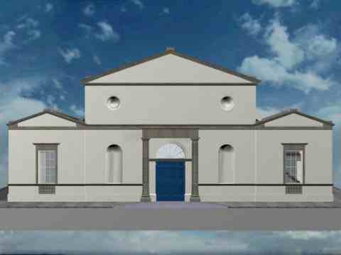
Nicolson Street in 1763. 

The Edinburgh Riding School was designed by Adam in 1763, five years after his return from Italy and setting up in independent practice in London.
Click to see large image.

The collapse, which has already been referred to, of the six-storey tenement building - "in which several reputable families lived", according to a contemporary account9- led to a survey of the state of repair of all such tenements in Edinburgh, resulting in a number of other buildings having to be demolished.  This drastic state of affairs called for a response, and in 1753 the City Council obtained an Act of Parliament "For Erecting several Public Buildings in the City of Edinburgh; and to impower the Trustees therein to be mentioned to purchase Lands for that Purpose and also for Widening and Enlarging the Streets of the said City, and certain Avenues leading thereto."  From this Act dates the series of civic improvements which transformed Edinburgh. 

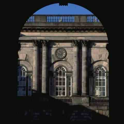
The first result of the 1753 Act was the building of a new covered merchants’ exchange, including a Customs House, as part of a large building, facing on to the High Street, mostly given over to shops, coffee houses, offices and residential apartments.  The Lord Provost of Edinburgh, George Drummond, the prime mover behind the whole campaign of civic improvements, commissioned a design from John Adam,10 and the Trustees accepted his design but awarded the building contract to a consortium of Edinburgh tradesmen rather than to the Adams, and the design was modified before being built.11  It is unclear whether Robert, who did not depart for his Grand Tour until the following year, would have had any hand in the design of the Exchange, but it was John, the elder brother and senior partner in the firm, who probably bears principal responsibility and who took the credit.  If Robert did play any part in the design, it was merely the first of many instances where he was to see his ideas modified while being executed by others.  The Exchange, today called the City Chambers and used as the offices of the Edinburgh City Council, is formed around three sides of a courtyard, with a screen wall across the fourth side to the High Street.  The covered exchange itself took the form of a deep loggia across the inner side of the courtyard, the ranges surrounding the open courtyard rising to four storeys in height. 

The next stage in the improvements, however, was critical.  In what was probably the largest public works project of its generation, in 1765 work started on a bridge to link the ridge on which the city of Edinburgh was founded (the "Old Town") to the next ridge of land to the north, crossing the Nor’ Loch.12  The North Bridge, as it was called, was undertaken ostensibly with the purpose of improving access between the Edinburgh on its ridge and its port of Leith.  However, the ulterior motive of the City Council was the development of the area to the north of the loch, much of which was in their ownership, as a new, spaciously laid-out, residential suburb, the Edinburgh New Town, within a newly-enlarged Royalty (the boundaries of the City Council’s authority), the Act of Parliament extending which was passed in 1767. 

The new bridge, running high above the east shore of the Nor’ Loch (drainage of which was begun in 1759) was of three arches, and was almost 70 feet high, a massive structure, with a roadway 40 feet between the parapets.  The building contract was signed in August 1765, and the bridge was opened to pedestrians early in 1769.  However, part of the side-walls of the south abutment of the bridge collapsed later that year, and the bridge, which had been due to be completed by November 1769, was only finally complete in 1772. 

Meanwhile, the vision of Provost George Drummond was realised in the laying-out of the new suburb on the empty ground to the north of the city.  In April 1766 a competition had been announced for Plans of a New Town.  Six sets of proposals were submitted before the competition’s closing date of 21st May 1766, and a seventh arrived late.  Three months later, it was announced that of the seven sets of plans, it had been decided that the best was that prepared by James Craig, the twenty-one year old son of an Edinburgh merchant.13

How closely Craig’s competition-winning design is reflected in the version that was formally adopted by the City Council in July 1767, and laid out thereafter, is unclear, since it is known that substantial revisions were made to the competition plan before its adoption.  The plan which was ultimately laid out is relatively simple.  It consists of three principal east-west streets, the central one connecting two formal squares, and the outer two of which are prolonged beyond the lines of the two squares.  These are connected by cross-streets at regular intervals, giving a grid-iron plan.  By the end of 1767, names had been assigned to the various streets and the two squares.  The main street along the axis of the New Town was named George Street, in honour of the king, George III (who graciously accepted the dedication of the plan when it was published), and the two squares which it connected were St Andrew’s Square at the east end and St George’s Square at the west.  Thus, squares named after the patron saints of Scotland and England, the two kingdoms of the United Kingdom, were symbolically linked by a street named after the king.  James Craig and the Edinburgh City Councillors had demonstrated their patriotism and loyalty to the house of Hanover.  The effect of this was diluted, however, when in 1785 it was decided to rename St George’s Square, Charlotte Square in honour of George III’s wife, Queen Charlotte. 

The Edinburgh New Town was intended as a purely residential suburb.  Apart from ground set aside for two churches to serve the inhabitants, no public buildings were shown on the plan formally adopted by the City Council in 1767 and, apart from the two "Back Streets," as they were termed on that plan (now Thistle Street and its extensions and Rose Street), which were intended for lower status residents, who would service the New Town, the New Town was to be an upper and upper-middle class refuge from the swarming streets and crowded tenements of the old city of Edinburgh.  Within a very short while, the Council’s policy changed, and on the map of the New Town engraved and published in 1768 a small square, labelled "Public Building," is shown on the site later occupied by Register House.14  This site, opposite the end of the North Bridge, is an obvious one for a large-scale building designed to attract the eye, and, in September 1769, concluding that the siting of the intended General Register House here "would turn out to the advantage of the City and would promote the feuing out of the grounds on the north of the Bridge,"15 the Council gave most of its required site to the Register House Trustees.  The Trustees commissioned Robert and James Adam to provide designs for their new building, and although construction was not begun until 1774, Register House was to prove a continuing advertisement in Edinburgh for Robert Adam’s abilities as an architect. 
 

Register House,the earliest purpose-built record depository in Britain, was designed by Adam and built under his superintendance from 1773 onwards.
Click to see large image.

Register House may have been the first, but soon it was not the only, public building in the New Town.  In 1775, James Craig was asked to design and to build a new Physicians’ Hall to stand on the south side of George Street,16  in a prominent site exactly mid-way along the first block of buildings, and in 1783 construction began of a suite of Assembly Rooms in the equivalent position in the second block, to designs by David Henderson.17  In 1782-4 a church was built on the north side of the road, immediately opposite the Physician’s Hall, and dedicated to St Andrew.  The Council may or may not have hoped to attract other public buildings for the equivalent positions in the other blocks, but development of the New Town, whether it had ever needed the encouragement of the siting of Register House there or not, continued steadily, and by the end of the 1780s the Council was having to consider what it intended to do about the final stages of the development, the west end of George Street and Charlotte Square.18
 

The Edinburgh New Town proved so popular that Charlotte Square, the last area to be developed, was designed by Robert Adam  in 1791.  Unlike the rest of the New Town, the buildings are integrated into unified terraces.
Click to see large image.

The method of development adopted for the New Town was that the City, having built up its holdings of ground and laid out Craig’s plan, providing sewerage and water supply, divided the street frontages into plots of ground which it then feued to applicants under standard conditions.  The first plots offered were at the eastern end of the New Town, particularly in St Andrew’s Square and the streets round about, but as interest built up other blocks of plots were offered for sale.  Some of the plots seem to have been gone to architect-contractors who would construct a house and offer it for sale, speculative development, whereas others went to prospective owners who would then employ the same contractors to build a house to their particular requirements.19  Whilst this procedure transferred the risk away from the city authorities to the speculative builder (from the eighteenth century onwards, bankruptcy has been a hazard of speculative building) its disadvantage was that, with each house built individually there was no overall control of the design process, resulting in monotonous and rather undistinguished street facades.  The standard conditions imposed by the Council were very general, covering the number of storeys and the heights of buildings, although even here some builders managed to evade them.  On the whole, however, the proportions of the facades are very similar, and the roof-lines are continuous, although the details of the individual houses differ, for example, in the doorcases.  Nevertheless, at least one contemporary critic complained of the poor proportions of the buildings, likening them to a Barracks.20

Individual houses in the New Town were designed by very prominent architects.  Sir William Chambers designed houses in St Andrew’s Square, and Robert Adam designed several houses, although only one was built in the New Town proper.  This was one of the first houses to be built in Queen Street, No 8, dating from 1770-71, which was built for the judge Baron Orde.21  The house is five bays wide as opposed to the normal New Town pattern of three, but the details, particularly the doorcase, were widely imitated during the development of the New Town. 

It had always been expected that the two Squares would turn out to be the most popular locations in the New Town and so, when the time came to consider the development of Charlotte Square, the Council decided to try a different approach to that of the rest of the New Town.  Difficulties over ownership of part of the site, which had opened the possibility that the New Town might have acquired a Circus or a Crescent in order to occupy less ground, were resolved, and it was decided that the facades of Charlotte Square should be built to a unified design.  Both Robert Kay, who was chosen as architect for the South Bridge over Robert Adam, and James Nisbet were at different times asked to provide designs,22 but in October 1790 the Lord Provost, James Stirling, commissioned a third design for Charlotte Square from Robert Adam, and this was - more or less - the one which was built. 
 

The terraces around Charlotte Square are built as "palace-fronts" disguising terraced houses.  On the right is a detail from one of the houses pictured on the left.
Click to see large images.

Adam’s designs for Charlotte Square set a new standard for urban design in Edinburgh.  There had already been one or two examples of unified designs for terraces, notably Adam’s own designs for South Bridge and Robert Kay’s pedestrian versions which were built in their place and also, slightly earlier, James Craig’s well-proportioned but rather plain designs for St James’ Square.  Even though they have been criticised for the conventionality of their composition - centre and end pavilions connected by lower-key linking blocks - the Charlotte Square elevations have an elegance and a sophistication far beyond those of Adam’s rivals, and demonstrate his mastery of the difficult task of uniting the facades of a terrace of houses into a single frontage.  Adam, with the experience behind him of designing The Adelphi and his other urban schemes in London, was regarded by his contemporaries as particularly skilled at designing such unified facades.   Adam’s designs for Charlotte Square were to exert an immense influence on his successors, and in the designs for the so-called Second New Town, laid out to the north of the first in 1802, and subsequent developments such as the Moray Estate, each block was treated as a single architectural composition in the same fashion as the Charlotte Square terraces.  Thus, even though it took until 1820 for Charlotte Square to be completed, its influence was profound. 
 

In Charlotte Square, each block of houses is treated as a single architectural composition.  The centre of the north terrace, for example, seen on the left, contains not one house but three.
Click to see large image.

As well as the terraces surrounding the Square, Adam designed a church for Charlotte Square.  If this had been completed, it would have been the second church in the New Town.  The New Town’s first church, St Andrew’s, was placed on the north side of George Street, mid-way along the first block, immediately opposite James Craig’s Physicians’ Hall.  St Andrew’s was designed in 1781 by Major Andrew  Fraser of the Royal Engineers, with the help of David Kay, and it was built between 1782 and 1784.  The tower and spire, possibly also the work of Fraser,23 date from 1786-7.  St Andrew’s (today known as St Andrew’s and St George’s) is an oval building, the earliest such church in Britain.  Centrally-planned churches had been popular in Scotland since the Reformation, for example at Burntisland in Fife (1592) and at Hamilton in Lanarkshire (1732), designed by Robert Adam’s father, William, and oval churches were known in other European countries.24  The oval plan of St Andrew’s, however, has no precursors anywhere in Britain.  It has its imitators, though, notably at All Saints’, Newcastle (1786). 
 

The houses on Charlotte Square were built following Adam's designs more or less closely.  Alas, the church which he designed to stand on the west side was never built, but was replaced by one designed by Robert Reid in 1811.
Click to see large image.

The interior of St Andrew’s is well-preserved, and the detail, particularly the plaster ceiling, is very much in an "Adam" style, even if it is not by Adam himself.  But Adam’s church on the west side of Charlotte Square would have been even finer, a very sophisticated design which, had it been built, would no doubt today be classed as one of his finest buildings.  Externally, the design is full of movement, both towards Charlotte Square and to the rear, and internally, the central space beneath the dome would have been magnificent.  It is a great pity that Adam’s design was never realised, and that Robert Reid was allowed to mutilate the Square by erecting his own adaptation of Adam’s scheme. 
 

The church which Adam designed for Charlotte Square had a very dynamic design, and if it had been built it would undoubtedly today be considered one of his finest buildings.
Click to see large image.

Contemporary with the designs for Charlotte Square was the construction of the new buildings for Edinburgh University to the designs of Robert Adam and under his supervision.  Indeed, Adam was advised by Lord Provost Stirling that his elevations for Charlotte Square should copy the "Elagent Simplicity"25 of the street facades of the University and avoid over-elaboration which might well make the design too expensive to build.  The external facades of the University, the designs for which were prepared in 1789, were plain indeed, Adam saving the grandeur for the entrance front and some of the courtyard facades.  Had the rebuilding of the University been completed to Adam’s designs, it would have been the largest public building in Scotland (apart, perhaps, from Fort George near Inverness).  Adam designed it on a substantial scale with two courtyards, a small forecourt surrounded by houses for the Professors with, beyond it, a square main court ringed by the teaching accommodation, but expectations of financial assistance from the government were dashed by the outbreak of war with Revolutionary France, and the stream of private donations dried up for the same reasons, so that only a small fragment of the building Adam envisaged was constructed during the 1790s.  This project was seen as being the culmination of the civic improvements to Edinburgh envisaged by Provost George Drummond of some forty years earlier, but it was only completed, to a reduced scale, after the conclusion of the Napoleonic Wars. 
 

Part of the north facade of Edinburgh University, which Adam was advised by Lord Provost Stirling to copy for his Charlotte Square facades.  The design is plain indeed.
Click to see large image.


The courtyard facade of the west wing of the University, seen here framed by the entrance gate, is much more elaborate than the street facades.
Click to see large image.


The reconstruction of the University Buildings was the logical development of another project, which had opened up its site.  This was the construction of the South Bridge, construction of which began in 1785.  Although not as essential to the development of Edinburgh as the North Bridge, without which the expansion of the city to the north side of the Nor’ Loch would have been almost impossible, the steep ravine of the Cowgate on the south side of the Old Town was a serious hindrance to the development of the city, cutting the southern suburbs off from the commercial heart of the city along the High Street.  The southern suburbs were growing, although the housing which was being built was not on the whole of the same status as that in the New Town.  This was also a period of great improvements in communications throughout the country, with General Wade and his successor Major Caulfeild building roads in the Highlands of Scotland,26 London gaining new bridges across the Thames,27 and the improvement of the road system throughout England, Scotland and Wales.  A bridge or viaduct bridging the valley of the Cowgate would not only create an easy north-south route across the city, which is its role even today, but would act as an impressive entry to the Scottish capital for travellers from the south, not least from London. 
 

Travellers from the south, reaching Adam's South Bridge, would have been met by an Inn (left) and, opposite it, a suite of Assembly Rooms (detail on right).
Click to see large images.


South Bridge was designed to make a level entry into Edinburgh from the south avoiding the steep descent into Cowgate and up again.  Adam wanted it to be impressive, too, with a magnificent bridge (left) crossing Cowgate.


Robert Adam was particularly anxious to be commissioned to provide the designs for the South Bridge.  The scheme he prepared would have been over a quarter of a mile in length, and includes not only terraces of houses and shops lining either side of the bridge proper, the bases on which they stand running down the sides of the valley towards Cowgate, but also a new entrance facade for the University (an early version of the design which was built from 1789 onwards), an inn and a suite of Assembly Rooms, together with other buildings, all the latter facing on to the newly-formed stretch of road linking the bridge itself to the north end of the road with which it was to link, Nicolson Street.  Adam’s design, had it been accepted, would have formed a magnificent entrance to the city from the south, whereas Robert Kay, the architect who was employed by the Trustees to design the buildings on either side of the bridge itself (the University facade, Assembly Rooms and the other buildings beyond the bridge, at the south end of Adam’s scheme were not supposed to be included in the scheme), was unable to rise above the mediocre.  Kay’s designs were amended by other architects, but the results, which in large part still stand although at street-level modern shop-frontages have replaced Kay’s series of round-headed openings, can never have been an aesthetic success.  Kay, like Adam, designed these buildings with shops taking up the whole of the street level - apart from entrance doors leading to the two storeys of tenements above - and they quickly became, and have remained, very successful commercially. 
 

At the High Street end of his South Bridge scheme, Adam designed shops around a square (left).  The back of the building contains shops running all the way down the hill to Cowgate (right).
Click to see large images.

Kay’s buildings lining South Bridge run for little more than half the length of Adam’s scheme, which would have extended from the High Street to the Riding House or Riding School which he had designed in 1763, more than twenty years earlier.  During those twenty years, the rural surroundings of the Riding House had disappeared, and Nicolson Street had been largely built up.  Nicolson Square dates from 1765 and St Patrick Street and Square from the 1780s.28  Other landowners were offering feus for building on the north side of the city, particularly in the area to the east of the New Town, where the construction of the North Bridge had made Leith Walk into the main route from the centre of the city to its port at Leith.  Some of the buildings constructed here were houses of comparable scale to the best of those in Craig’s New Town, whereas others contained lower-status tenements.  York Place, laid out as a continuation of Queen Street in the New Town, contained both.  As part of this process - and also to raise money to assist with the completion of their building - the Register House Trustees decided to feu the ground they owned alongside Leith Street, and asked their architect, Robert Adam, to provide designs which they would require potential feuars to follow.  The two alternative designs Adam produced were, however, both rejected by the builders as too costly and as providing too grandiose accommodation for that area of the town.  The tenements which were built there followed even the lines of Adam’s design only partially.  Because of the fall in the ground, Adam’s houses were raised on a high basement, containing shops facing on to the street.  The centrepiece of the plainer of his two designs was reproduced in 1790 by another architect, James Begg, a little further down Leith Walk, as Gayfield Place.29

Further new buildings on this side of Edinburgh include the last realised design by Robert Adam for any public building.  This 
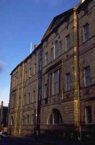
was the Edinburgh Bridewell.30  Expanding the jail accommodation in Edinburgh had not formed part of George Drummond’s vision for the development of the city, although the existing House of Correction was by the 1780s in urgent need of replacement.31  The Bridewell, the foundation stone of which was laid in Adam’s presence on St Andrew’s Day 1791, was completed in 1795, but the difficulties of funding public works projects during the Napoleonic Wars meant that Adam’s scheme of bridging the ravine at the east end of Princes’ Street, with a viaduct carrying the road across to Calton Hill to give access to the Bridewell and presumably connecting with the London road further to the east, had to be abandoned until the war was over.32
 

The Viaduct which Adam proposed to build between Princes' Street and Calton Hill was probably designed in connection with his winning a competition in 1791 to design a new Bridewell for the city.
Click to see large image.

The Napoleonic Wars caused great disruption to the development of many towns and cities throughout Britain, and Edinburgh was no exception to the rule.  Building ground to a halt in Charlotte Square almost before it had begun, and the University remained incomplete, with the east wing only partly roofed and decaying, for many years.  Private developments continued on a lesser scale: it was the large town houses, such as Charlotte Square, which remained unbuilt.  Both in the  New Town and on the south side of Edinburgh construction of slightly smaller houses and tenements continued, although the scale of development was probably less than it had been during the boom years of the late 1780s.  One building which was erected was St George’s Chapel in York Place,33 built in 1794 to designs by James Adam for a congregation of the Episcopal Church, although it is difficult to resist the suspicion that his brother Robert may have had some hand in the design for the manse next door, which is in his castle style. 

The eighteenth century closed in Edinburgh with the great boom in civic redevelopment over for the time being, choked off by the distractions of the war with France.  After the last of the available funds were exhausted in December 1793, work on the Edinburgh University buildings was halted,34 and it was to be 1815 before anything more then the most minimal work was done towards its completion.  Adam himself had died in March 1792, almost at the beginning of the war, and his death, together with the abandonment of the building which he had begun with such high hopes in 1789, is the perfect symbol of the conclusion of the great eighteenth-century civic redevelopment of Edinburgh, which could only begin afresh in the new, post-Napoleonic era. 
 

 interactive multimedia catalog


 Published by Cadking Design Ltd, Edinburgh, Scotland - Copyright © Cadking Design 1997-2001
Last Update 14 June 2001- Optimised for IE5+ and Netscape 4.5+


keywords: Robert Adam, architecture, Georgian Architecture, C18 architecture, urban design, visionary architecture, architectural visionary, visionary, architectural, architectural design, Development of eighteenth-century edinburgh, Edinburgh's New Town, New Town, Edinburgh, Scotland, Vision of Edinburgh, Julian Small, Sandy Kinghorn, Cadking Design Ltd, visual catalog, visual catalogues, interactive multimedia catalogue, interactive multimedia catalog, multimedia catalogue, multimedia catalogue, architecture catalogue, architecture catalog

James Craig, John Adam, Robert Reid, James Nisbet, William Chambers, David Kay, Major Andrew Fraser, church design,centrally planned churches, Edinburgh University, George Drummond, Provost, Din Eidyn, Flodden Wall, North Bridge, South Bridge, Queen Street, Register House, Charlotte Square