|
-------------------------------------------------------------------------------------- |
||||||||||||||||
|
VIADUCT OVER THE LOWER CALTON |
||||||||||||||||
|
Essay by Julian.Small |
||||||||||||||||
|
|
------------------------------ |
|
||||||||||||||
|
|
Until the completion of the new North Bridge in 1772, the principal
access from Edinburgh to its port of Leith had been through a
"mean and squalid" suburb,1where
the butchers and cordwainers (leatherworkers) had their
premises. This suburb, on the site where Waverley Station now
stands, was hemmed in to the north-east by the steep slopes of Calton
Hill, and the route to Leith lay through a deep ravine between Calton
Hill and the ridge on which the Edinburgh
New Town was laid out from 1767 onwards. The road along
this ravine was called either the Low or Lower Calton, or St
Ninian’s Row, and today forms part of Calton Road.
The building of the North Bridge, however, had by-passed the Lower Calton, and traffic between Edinburgh and Leith now crossed the east end of Princes’ Street. The Edinburgh New Town had been intended as a purely residential suburb, with houses looking out to both north and south onto landscaped gardens. But whilst the houses to the north retained their essentially domestic character, along Princes’ Street to the south commercial interests fairly soon began to appear,2 a process which has culminated in its being the main shopping street in Edinburgh.
By the beginning of the 1790s, this process was already under
way. Robert Adam’s own Register
House, the site for which was granted to the Trustees by the
City Council in 1769, was not commercial in purpose, but neither was
it residential. The
terrace of houses which Adam designed for Leith Street on behalf
of the Register House Trustees in 1785 contained some purpose-built
shops in the basement storey, and it is recorded by the end of the
1790s that most of the premises at the east end of Princes’
Street were in commercial use. In addition, the City
Authorities were proposing to develop buildings on the slopes of
Calton Hill. The logical next step must have appeared to be the
linking of the east end of Princes’ Street and Calton Hill,
where the new Bridewell designed by Adam was soon to start
building. And it would appear very logical that such a linking
bridge should, like Adam’s unexecuted designs of 1785-6 for
Edinburgh’s South Bridge
(and like the completed scheme of 1785-8, which drew much from
Adam’s project) be lined with shops and houses along the two
sides. Such a bridge could also have led to join the road from
the bottom of the Canongate which was the precursor to today’s
A1, the Great North Road. The new bridge would have formed a
magnificent triumphal entry to Edinburgh from the main route from the
capital of the United Kingdom.
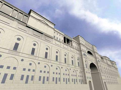
The impressive design to which this computer model relates exists in
only one drawing,4
a view from the north, showing a - somewhat idealised - perspective
view of the ravine, with the viaduct seen side-on. The viaduct
towers up out of the valley, with North Bridge and the dome of
Adam’s Edinburgh University visible in the background to the
right, and, beyond the left-hand end of the viaduct, an elaborated
version of the monument designed by Adam himself to the philosopher
David Hume, his personal friend. Further to the left is an
Italianate design for the new Bridewell. It is a preliminary,
sketch design, intended to impress his potential client, in this case
Provost Stirling, and it is for this reason that a dedicatory
inscription referring to Stirling, in the same fashion as the one
above Adam’s entrance to Edinburgh University, is shown above
the bridge arch. The drawing itself reflects Adam’s taste
for landscape watercolours, with contrast between light and shadow
and the dramatic qualities of the landscape setting, all of which
provide parallels with Adam’s desire to present a sense of "movement"
in his architecture.
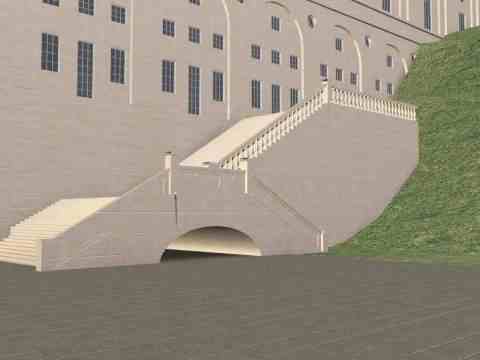
The castellated design for bridging the Lower Calton is not only of more modest dimensions than the Viaduct which Adam had first envisaged. It also omits all the buildings lining the roadway. Like the bridging of the Lower Calton at the foot of the Viaduct, the main vehicle arch is flanked by two pedestrian arches, the former marked as eighteen feet wide and both the latter six feet. Again like the Viaduct design, steps descend the wing-walls of the bridge, presumably continuing (although this is not shown on the drawing) to the foot of the ravine. The roadway along the top has castellated parapets and, as is common in eighteenth-century bridges, four semi-circular pedestrian refuges above the main bridge piers.
It is not hard to find the reasons why neither bridge design was
built. The outbreak of war with Revolutionary France, a war
which was to continue almost without intermission until the Battle of
Waterloo in 1815, was a serious setback for all building
projects. Central government refused to spend money on building
projects during wartime; public authorities of all kinds found it
difficult to raise capital for construction works, and even private
building was much affected. Some building projects, such as Edinburgh
University, partly complete in 1791, had to wait until after
1815 for completion and - although not in Edinburgh - some
speculative housing developments were abandoned for just as long a period.11
Completion of the new Bridewell was a priority, whereas improving
the access to it from Princes’ Street could afford to be
postponed. In 1813-14, moves were made towards the construction
of a bridge in this location, and in November 1815 Archibald Elliot
was appointed architect, Robert Stevenson having already been
appointed engineer.12
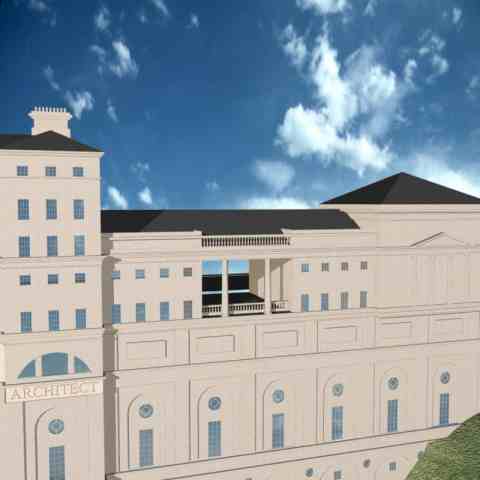
Like Adam’s design, the bridge built by Elliot is lined with
buildings. The difference lies in the fact that whereas in
Adam’s design the buildings rise to their tallest in the centre
of the viaduct, above the bridge, and there are viewpoints from the
bridge abutments, in Elliot’s executed proposals it is the
approaches to the bridge which are lined with buildings, and the arch
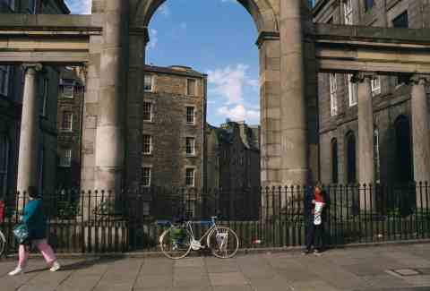
bridging the Lower Calton which is surmounted by a screen of Ionic
columns. This is very similar to Adam’s alternative design
for the arch over Cowgate in his South
Bridge scheme,13
and it is likely that Elliot had seen copies of Adam’s drawings
for this, and quite possible that he knew of Adam’s scheme for
the Calton Hill Viaduct. The buildings flanking the bridge
approaches have five floors of basements below street level, and the
arch of the bridge itself rises fifty feet above the Lower
Calton. So big was the job that it was not finally completed
until January 1822, construction of bridge and road across Calton
Hill having cost almost £40,000, an immense sum.14
By comparison, construction of the South Bridge, with its nineteen
arches, between 1785 and 1788 cost approximately £15,000.15
Only thirty years after his death was Adam’s vision of a
monumental entrance to Edinburgh from the east realised in the Regent
Bridge and - inevitably for that date - Waterloo Place.
|
|||||||||||||||
interactive multimedia catalog
|
||||||||||||||||
|
Published
by Cadking Design Ltd, Edinburgh, Scotland - Copyright © Cadking
Design 1997-2001 |
||||||||||||||||